Thursday, June 23, 2016

June 23 - The Waiting Game

Being in town is so different from being on the trail, there isn't quite the same routine of getting up early in the morning, packing up all of your stuff while your hands freeze, and then hitting the trail taking it one step at a time until you stop to eat, start walking again, and then unpack all your stuff and set up camp for the night. In town you have to consider where you're going to eat, what you need to buy, how you're going to get back to the trail, and what you're going to do all day long while waiting for the evening to come and sleep. It's a whole different and somewhat uncomfortable routine. The other hikers seem to feel it too. The younger group tends to sit around and shoot the bull, drinking, smoking, or sometimes sleeping. Us older people, if we can connect, do the same, or we're left out and need to find our own happy place. A few of the young kids make the effort to include me in conversation if only for a while. I'm reluctant to intrude, especially since I've just come back on trail and haven't shared their specific journey in the same way. 


Tomorrow I'll rejoin the trail. I replaced a broken squeeze bag to go with my water filter, bought a new gas canister, and bought a few food items I know I've missed in my resupply. I'm leaving a few familiar faces, but I'm sure I'll meet up with some of them again.  At least I hope so. The hostel has been a good place to be, but hiking solo is what I'll do again until I can find another friend on the trail. 


Happy Trails,


Hikingsolo

June 22 - Kearsarge Pass to Independence and Bishop


Independence isn't much of a town and my resupply wasn't yet there so I hitched a ride with Mountain Goat to Bishop and the Hostel California. 


Yesterday I hiked to within two miles and 1000 feet of Kearsarge Pass and the camped on a ledge overlooking the lakes below. Today I crossed over with a zillion other hikers to make the five mile descent to the Onion Valley trailhead where Michael, brother of another Trail Angel, Larry, who I mentioned previously, picked up hiker trash for the quick descent into the desert. He dropped us off at Subway and then returned up the mountain for another batch. After a quick sandwich it was time to check on my box, secure a place at the hostel, and then hitch a ride north to Bishop. 


A nice former Mountaineer and her daughter picked Mountain Goat and me up on their return trip from backpacking in the mountains around Lone Pine. She dropped us off in the parking lot of the hostel about an hour later. 


The hostel was packed with people I had met on the trail. That included two hikers I hadn't seen for about six weeks, Hatchet and Crocs. It was great to see them again! They had been hanging around Bishop at the hostel doing odd jobs and climbing or hiking sections of the PCT. 


If you've never been to Bishop now may not be the time to come because it is so hot here. However, you can cool off with a beer at the local brewery which just opened in the last year and has a great IPA and awesome food. You'll know which one it is because there's only one in town.


The rest of the day was spent doing laundry, taking a shower, and visiting with new and old acquaintances. 


Hikingsolo

June 21 - Forrester and Kings Canyon


Fish Nugget wanted to sleep in but was up early due to the cold. Although it didn't freeze it must have come close, and the high altitude probably didn't help her either. So we packed up and started up the pass just as the sun hit our campsite. Most of the pass stayed in shadow as we crossed the largest snow field and approached the first switchback. As we walked ahead in our microspikes we noticed many of the places the last hiker of the previous evening had slid and postholed. I really though he might have turned around with the snow so soft but he must have made it because we didn't see his body anywhere. This morning the snow below the pass was hard and easy to walk across due to the spikes on our shoes. We had no trouble on any of the snow on our way up, but the way down was different. 


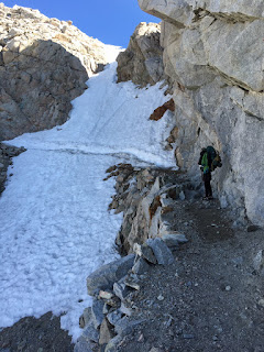
Forrester is named after the group of forest rangers who first traversed it. Later came a trail crew who lost one of their own during construction. We passed his memorial on the way up and could see how dangerous it must have been to build this magnificent trail. I was certainly in awe. The trail traverses a slot in the mountain that is covered in snow and ice much of the year. Today was no exception and it proved to be the most thrilling and potentially dangerous part of the climb. 


Once at the top we thought we would have an easy walk down but the snow on the east facing slope was already soft and slushy. Our first snow crossing found us sliding and postholing most of the way. There was so much snow between rocky outcroppings that we had to take it very slow. At one point I slipped and slid down a short slope on my derrière. When I tried to get up I slipped again and from that point to the bottom I just used my hiking sticks to push me along. It was kinda fun!


The rest of the hike took us down into Kings Canyon, a most spectacular place. Water was crashing down the many streams and we got wet all along the way. The canyon is surrounded by high rugged granite peaks. 


Toward the end of the day Fish Nugget and I said our goodbyes as I headed toward Kearsarge Pass and Independence to resupply and she headed toward Mammoth and a meetup with her mom. We hope to meet again on the trail. 


Tonight I'm camped on a granite ledge above some beautiful lakes just west of Independence. Tomorrow I'll make the descent into the valley and collect my box. Other hikers are encouraging me to hitch to Bishop as the amenities there are better. I'll see how the day goes. 


Fish Nugget ready to put her microspikes to use. 

Forrester's snow chute in the background. 

Selfie


Near the top. 


Crossing


We made it up!


The path down. Where?

Looking back into Kings Canyon. 


Sunset 


Hikingsolo

June 20 - Towards Forrester Pass


Last night I checked my maps, electronic ones since I somehow left my paper maps got the area past Whitney at home in my next resupply box, only to discover that my itinerary did not match up with reality. My itinerary said I had 12 miles to go to the turnoff to Onion Valley and my next resupply. The reality was 12 miles to the first and highest pass on the PCT, Forrester, at 13,200 feet and then another 16 miles to Onion Valley also over a high pass. So today I woke up feeling a little like a dufuss with two or more long days ahead. 


I also woke up a little sick to my stomach, I think from over exertion the day before. I stayed in bed a little longer to allow my body to recover and then thought about eating. Breakfast stayed down and seemed to give me some energy. 


Along the way to Forrester Pass I met a few other hikers: Dr. Nuggs, who was a pharmacy on foot, and his cousin Professor Kind, a frequent user of the pharmacy; Feldspar, a young woman on the trail alone; Wildfire, with red hair and wild pants, and her (boy)friend Catnap;  Rainbow from New Zealand; and Fish Nugget. 


Fish Nugget, aka Sydney, is a nice  young lady from Truckee who has worked on organic farms and seems to love the farming way of life. She's on a mission to redefine her life view while on the PCT. Fortunately for me, she likes to take it slow and likes to talk. We hit it off great and walked the last five miles or so to the base of daunting Forrester Pass. This was very fortunate as I really needed to recover from the climb up Mt. Whitney. As we approached Forrester the time was late so we made camp at the last possible spot. We shared some dinner and a packet of awesome hot apple cider before the sun went down and it starred to get cold. Well sleep in tomorrow to allow it to warm up before we attack the pass. 


Sorry if some of the pictures are a little small. I'll edit when I get to a computer. :-)


Hikingsolo

June 19 - Whitney


On top of Mt. Whitney, all covered with snow,

There was this old teacher, too worn out to know.

Better. 


The hike up was one that took my breath away, literally. I was about to turn around at 12,787 feet. My chest hurt, my back hurt, and it seemed like I took a break every few hundred feet. A few hikers coming back from moonlight summits said to just keep on going, one step at a time. Of course they were going downhill. Easy for them to say. I started at 7:00 and finished summiting around 1:00. Downhill was marginally faster but I took care with my finicky ankle. Dinner was ready around 7:00. That made for a long and arduous day. Here are a few pictures. 


Hikingsolo


When I'm home and getting up early to climb Tummamoc Hill I skip breakfast until later. That's what I did today. I hit the trail at 7:00, before most other hikers were up. They caught up to me though as the first six miles were uphill and I wasn't in my best shape. The first to catch up was Enda from Oregon. I think of her as Snow White because that is the color of her hair. Later came Pitter Patter and Town Food. Then I played leapfrog with the hordes. 


Several groups were going out at Horseshoe Mesdows for resupply in Lone Pine. A few are doing like me, keep on trucking to Whitney and then resupply in Independence. The next two days will tell me if I can make it up Whitney. Last night I had a terrible headache due to the abrupt change in altitude. I'm hoping that a couple of days in the 11000 foot range will help me get acclimated. I should have enough food to last an extra day but if I don't get a ride quickly to Independence I could be hungry for a bit. 


Pictures: selfies, camp, and hikers hanging out trying to get a cell connection (they never did).


Hikingsolo

Sunday, June 19, 2016

June 15 - Back on the Trail Again


Betsy sent me off with one final geocaching adventure down the PCT outside of Kennedy Meadows, a kiss, and an admonishment to take it easy and be careful. My intention was to take it very easy, which I partially succeeded in doing, with only a minor ankle roll in the first quarter mile and another in the last mile before I stopped for the day. 11.5 miles in all. And my legs and feet felt every inch of it!  Five weeks off the trail hurt! Tomorrow will be better I am certain. 


Today I met the backside of the herd and several characters that accompany it. Legend and Raven were in the campground after a short reconnaissance of the trail looking to do Trail Magic. Dirty Sink and her boy Forward were at the store just hanging out while resupplying. Honey, PushPop, Tindy, and too many others to remember were on the trail. Camping was a challenge to find a place away from the music and carousing but I was persistent and found a spot. Later I visited the other camps to just say hello. Nice group! 


Here are a few pictures. 


Obligatory selfie at the start. 

Trail Crew. All volunteers. Thank you!

My camp. 

The hordes. 

PitterPatter on the bridge across the south fork of the gently flowing Kern River. 

The river at sunset. 


Hikingsolo

June 16 - An Uneventful Day


About half of the camp had left by the time I hit the trail at 8:00. It turned out that by the end of the day every one of them along with a few others arrived at the same camping area I chose weeks ago. 


I played leapfrog with several hikers as we took breaks at different times. The only one I didn't leap was PitterPat. She passed me as if on a mission. Tonight in camp I wondered how she looked so clean and fresh. I suppose it was because she had arrived hours earlier and had time to rest and freshen up. 


Many hikers are resupplying at Lone Pine in a couple of days. That should break up this bubble. Others are doing as I will, resupply at Independence after trying to go up Whitney. I checked my itinerary and I'm not sure I'll make it up Whitney. Somehow I scheduled a 24 mile day. I don't think that will happen considering how my feet and legs feel after weeks off the trail. Time will tell. 


Sorry, only one picture. I wonder what this plant is? It sure stood out!


Hikingsolo

Saturday, June 18, 2016

June 18 - In the Shadow of Whitney


Today was one of the hardest hikes I've done on the PCT, or anywhere for that matter. I stopped last night at mile 747, Poison Meadow Spring, two miles further than I anticipated. That made today's hike two miles shorter, 20 instead of 22 miles. There were several elevation changes totaling 4500 feet and topping out at just over 11,000 feet. Needless to say I'm exhausted! I left at 7:00 this morning and got into camp at 6:30 this evening. After filtering water, setting up the tent and sleeping arrangement, cooking dinner, and then eating I'm definitely ready for bed. 


The camp area is at Upper Crabtree Meadows, just 7.5 miles from the top of Mt. Whitney. I'll join a large loose knit group on the way up tomorrow. In the morning there won't be much sun as I'm camped in the shadow of Whitney at 10,500 feet and I expect the night to be cold! If all goes well I'll get up and back before dark. I'm not planning on taking much, just lunch and water, so the trip should be easier on my body. 


Today I met Dangerous Dave, Gilbert (who was on a train to LA with SnapChat), and Night Rider. Nice people. 


Pictures: Chicken Spring Lake, the first one in the Sierra along the PCT. 

Elevation, but not the highest today. I think that was over 11,600.

Looking towards Whitney. 

The trail is all about the same with magnificent trees and lots of granite, decomposed and solid. 


Hikingsolo

Tuesday, June 14, 2016

June 5 to 14 - Lullaby


My visit with Jake at Agility physical therapy seemed to confirm a multiple sprain affecting the connection between two ligaments in my right foot. One crosses over the top of the foot from the big toe to the heel and the other runs from the knob on the outside of the foot up behind the ankle bone towards the knee. Where they cross is connecting tissue that may have separated causing the pop I heard. Over the last week swelling and pain have subsided, but soreness persists. Tomorrow I start back on the trail where I left off at Kennedy Meadows. I'm hoping that the foot will hold up to the rigors.  Recent walking has been fine, but a small twist could be a problem.  I'm planning on going slowly the first few days to be safe. I have about three days to get up to 10,500 feet from 7200, so that should be doable. Next comes Whitney, which I plan to make a day hike. I expect that I won't have any phone reception for most of the next 8 days so this could be the last you'll hear from me until I come down to Independence for resupply. 


Over the last week I took it easy until Betsy and I met up with friends in Flagstaff for a little geocaching adventure. We drove and walked the hills southwest of Flag to acquire the Saturn Revisited series. I walked a number of the cache sites which turned out to be good for my foot and my confidence on rough terrain. After a full day in flag we trekked to Page with geocache stops along the way. The prize we reached on Monday at the North Rim of the Grand Canyon. I've always wanted to visit but never had the time. Betsy and I walked out to view Bright Angel trail from the area around the Visitors Center.  Betsy was a little afraid of the drop offs, but I held her hand! Later we drove back roads to a Marble Canyon overlook where we retrieved another cache and spotted a forest fire deep in the canyon. That night was spent in St. George, Utah, just a hop skip and jump from Warren Jeffs' playground at Colorado City. Tonight we are back in Ridgecrest, at the foot of the Sierra. I've checked my gear and found a couple of things that need attention. Betsy will send me off again in the morning and return to Tucson to take care of Nanna and Sammy. I've had a restful good time waiting for the snow to melt, but now it's time to get on the trail again. October and snow is just around the corner. 


The old Schoolhouse cache in Strawberry. 

KennyV climbing down after completing Saturn. 

Navajo Bridge near Lee's Ferry. 

It's not really a drop off to your left!

Looking down at the North Rim. 

Earth Cache. 


Gear. 


Hikingsolo

Sunday, June 5, 2016

June 5 - Improvement


The foot continues to improve. No call from the radiologist may be great news. I'm keeping my physical therapy appointment on Tuesday to talk with a sports expert about how to best proceed. My hope is that all will be good by the 15th. Wishful thinking?


Hikingsolo

Friday, June 3, 2016

June 3 - Disaster Strikes

Suffice to say that after two months and 702 miles of trails, along with several rolled ankles and a couple of falls, I wasn't prepared for stepping on medium sized igneous rock in Show Low.

While throwing tree trimmings into a trailer I stepped directly on a rock with the mid-sole of my foot and heard a pop! That was followed immediately with pain that stopped me in my tracks for a few seconds. I continued to walk, albeit gingerly, and completed several chores before I took a break. The next thing I did sealed the deal - I attempted to put the awning out on the trailer using a footstool to get up high enough to grab the strap. I stepped on the edge of the stool and rolled off onto the side of my injured foot. No popping, but damn did that hurt!!!

Research into foot injuries told me that it wasn't likely broken, but it still hurt and was turning colors. When Betsy got back I iced it and took an aspirin. Later in the evening we talked about having it checked out in the morning as it wasn't feeling any better.

The doctor says that it's likely a sprain. He sees no broken bones, but he's sending the X-Rays to a radiologist who should call later today. Then he gave me a shot to reduce the swelling. If there is a stress fracture it won't show up on the X-Rays for several days, so if by Tuesday it's not feeling better I'll have to have it X-Rayed again! Of course I have a PT appointment on Tuesday to look into that foot - I guess I'll have to cancel.

My bigger worry is that I won't be able to get back on the trail on June 15th. That will delay my return even longer! I guess I should be thankful that I'm not wearing a cast, but, gosh darn, what a horrible way to get off trail.

May 25 to June 2 - Life in Tucson

Life in Tucson is just about as normal as it can get. Up 750 feet and 3 miles round trip on Tumamoc Hill in the early morning followed by a four or five mile walk home. Later some shopping and planning for the hike to come. Visits with family in between. Trying to keep my diet in check.

I'm anxious to get back on the trail, but that's not happening anytime soon. On June 11 and 12 I'll travel with Betsy to Flagstaff and from there back to Kennedy Meadows where I'll pick up again. I'm excited to see that Hatchet/Danger and Snapchat have made it safely to places in the Sierra despite the snow and ice.

I made an appointment with Jake at Agility Sports and Spine Physical Therapy to look at a problem I developed in my right foot while going up the hills in Berkeley. I think I stressed something a bit. Not broken, but not feeling all that good either. Next Tuesday I should have some idea of how to treat it.

The Memorial Day weekend sale at REI left me minus lots of money as I bought supplies for the trip along with a long sleeved wool layer. I've been wearing a synthetic layer that does a good job of keeping me warm,  but it stinks fairly quickly. My wool shirts don't stink, even after five days of sweating, so wool it is!

This week we'll be headed up to Show Low for a little escape from the Tucson heat. I plan to continue walking at the 6800 foot elevation so I'll stay in shape for a return to Kennedy Meadows.

May 24 - Back to Bridgeport for a Night

On the morning of May 24th Betsy and I headed out again for Bridgeport on our way back to Tucson. Rest assured that I'm not returning to Tucson for the summer - I'm planning on being back on the trail as soon as June 15th. By that time the snow will have melted and the high passes, Forrester and Kearsarge, should be passable.

We stopped over night at the cabin to pick up some things we left behind, like crampons and snow pants! When we arrived late in the day we took a little walk around the area and discovered neighbors Holly and Doug were at home. Plans were quickly made for a post dinner happy hour. Later on we met their friends and swapped stories.

In the morning we were back on the road, headed for Tucson by way of the northern reaches of Death Valley. Betsy had a few caches she needed in some remote areas of California and Nevada, so we took the less traveled road to get them. That road included the Bristle Cone Pines National Forest where we met a ranger who proudly told us of the role the University of Arizona played in dating the trees. Who knew? Actually, we told him that a friend was one of the UA Tree Ring lab researchers and he had helped us to core and date a tree in front of the cabin. Its such a small world!

Later that day we pulled into Beatty Nevada for a stay at the Motel 6. They left the lights on for us.